Proposed Bus Turnaround Archaeological Report, Block 28 & 34Originally entitled: "Results of the Archaeological Testing Project for the Proposed Bus Turn-Around, Block 28 and 34"
Colonial Williamsburg Foundation Library Research Report Series - 1618
Colonial Williamsburg Foundation Library
Williamsburg, Virginia
1990
RESULTS OF THE ARCHAEOLOGICAL TESTING PROJECT FOR THE PROPOSED BUS TURN-AROUND, BLOCKS 28 AND 34
Department of Archaeology
Office of Excavation and Conservation
Colonial Williamsburg Foundation
February 27, 1985
INTRODUCTION
A bus turn-around is proposed to be constructed at the intersection of North England Street and the access ramp leading to the Colonial Parkway (a modern extension of Scotland Street). Construction of the bus turn-around will necessitate grading operations. As such, the project will adversely affect the current topography on the north and south margins of the access ramp leading to the Colonial Parkway from North England Street (Figure 1).
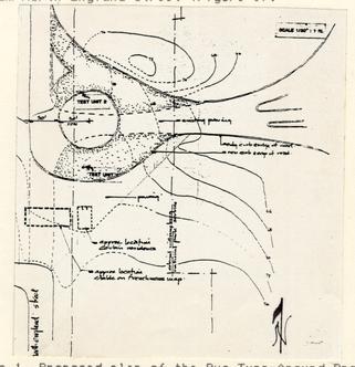 Figure 1. Proposed plan of the Bus Turn-Around Project (C.W.F. Architecture Department 1984).
The access ramp leading to the Colonial Parkway had been constructed sometime after 1935. It was in that year that the U. S. National Park Service acquired the property (Foster 1984, Derry 1984). Hence, this particular area had been disturbed. However, the exact nature and extent of the disturbance was unknown, as no records of the construction exist.
In addition, a house had been located on the north side of the access road, upon the knoll (Edward Spencer 1985, personal communication; Derry 1984). The small 20th century structure was razed after 1933, as a Sanborn map shows it in place at that time (Derry 1984). The area that was affected by the development and destruction of this modern structure was unknown, prior to this excavation. Apparently this portion of the "Historic Area" was never investigated by C.W.F. archaeologists. Therefore, the Office of Excavation and Conservation decided that a preliminary testing project was needed in order to ascertain: 1. the stratigraphic contexts on each margin of the access road and 2. the presence of cultural features, in these particular areas.
EXCAVATION PROCEDURES
A grid system was used in establishing the location of the test excavation units. This grid system was coordinated with the grid used at the Peyton Randolph Site. Therefore, a 4 north/south baseline was extended north from the grid stake designated as 50 North, 0 East, up to a stake designated as 700 North, 0 East. The baseline was situated along the east margin of North England Street (Figure 2).
 Figure 2. Plan of Block 28 and Block 34. Figure shows baseline and Test Units 1 and 2 along the east edge of North England Street. (C.W.F. Block and Building Book 1980).
Two test excavation units, 2.5 feet squares, were established using thee aforementioned grid system. Test Unit 1, denoted as 595 North, 25 East was located at the southeast corner of the North England Street and Colonial Parkway access road. Test Unit 2, designated as 677.5 North, 25 East, was situated at the northeast corner of the intersection (Figure 1).
Horizon A (topsoil) and Horizon B (subsoil) strata were removed by hand excavation. This excavation was effected by shovel scraping and troweling. All soil was screened through a 1/4 inch mesh screen. Artifacts were separated by each respective horizon in each unit (Appendix 1). Soil samples were extracted for laboratory analysis.
Both excavation units were mapped in the planview (horizontal) and profile (vertical) formats. Black and white, as well as color photographs were taken for corresponding planview and profile subjects.
Time constraints would not permit lengthy excavation of the test units. Therefore, after ca. 0.1 foot of Horizon B was hand excavated, an auger (hand operated) was used to determine the depth of Horizon B in the respective test units.
RESULTS OF EXCAVATION
Based on the test excavations the areas on either side of the access road to the Colonial Parkway appear to be disturbed. Test Units 1 and 2 produced similar stratigraphic profiles (Figures 3, 4, 5, and 6).
 Figure 3. Profile of the South wall of Test Unit 1; 595 North, 25 East. Note Horizons A and B.
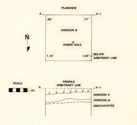 Figure 4. Planview map and South wall profile map of Test Unit 1; 595 North, 25 East.
 Figure 5. Profile of the East Wall of Test Unit 2; 677.5 North, 25 East. Note Horizons A and B. Also note Feature 1 in the Horizon B floor.
 Figure 6. Planview map and the East wall profile map of Test Unit 2; 677.5 North, 25 East.
Test Unit 1 contained Horizons A and B (Figures 3 and 4). Horizon A consisted of a very dark brown (10 YR 3/2-wet) (Munsell Color 1975), sand loam. Artifacts consisted of machine made glass, sand mortar, coal and gravel. This horizon appears to represent topsoil fill deposited during and/or after the ca. 1950's. Horizon B consisted of a brownish yellow (10 YR 6/6-wet) (Munsell Color 1975), clay sand. The matrix contained red hematite and gray clay inclusions. Artifacts recovered from the Horizon A/B interface included glass, shell, metal, brick, coal, and gravel. Small brick fragments were the only artifacts recovered below the stratigraphic interface. These diminutive artifacts were probably deposited through root action. Horizon B represented an in-situ subsoil.
Test Unit 2 contained Horizons A and B (Figures 5 and 6). Horizon A consisted of a brown (10YR 5/3-wet) (Munsell Color 1975), sand loam. Artifacts consisted of glass, brick, coal, clinkers, and gravel. This matrix appeared to represent a topsoil fill horizon and probably post dates the 1950's. Horizon B consisted of an brownish yellow (10 YR 6/6-wet) (Munsell Color 1975), clay sand. This matrix contained red hematite and gray clay inclusions. A small number of brick, coal, and gravel artifacts were recovered from the Horizon A/B interface. Small brick fragments and 11 gravel were noted below the stratigraphic interface. Horizon B appeared to represent as in-situ subsoil.
Both Test Units 1 and 2 were augered with a hand auger from the respective Horizon B excavation levels. Test Unit 1 was augered to a depth of 2 feet below the excavated Horizon B level. Test Unit 2 was augered to a depth of 1.5 feet below the excavated Horizon B level. Both augering operations produced a continuation of Horizon B to the depth of the auger hole, within each excavation unit.
One cultural feature (Feature 1) was encountered during the testing project (Figure 7). Feature 1, defined as a post hole, contained a dark brown (10 YR 3/3-wet) (Munsell Color 1975), sand loam. Artifacts recovered from the feature included gravel and a nail. The temporal affiliation of the feature is the 20th century. This observation is predicted on the recovery of an 8p common nail, which was manufactured during this century (Nelson 1968). Although the feature was defined as a post hole the exact association of the feature is unknown. For instance, we do not know whether the feature was associated with the razed house, or on the other hand, a C.W.F. or N.P.S. street sign.
12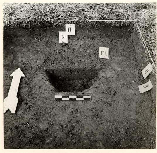 Figure 7. Profile of the North wall of Test Unit 2; 667.5 North, 25 East. Note Horizons A and B. Also note cross-sectioned Feature 1.
SUMMARY AND RECOMMENDATIONS
In conclusion, the excavation of Test Units 1 and 2 produced negative evidence for the presence of in-situ 18th-century stratigraphic horizons or cultural features. The test excavations revealed Horizon A, an ephemeral fill horizon, which functioned as a modern topsoil. Horizon B was situated directly under Horizon A. Horizon B, a subsoil, was apparently exposed during an episode of grading operations. Therefore, any 18th-century occupation horizons and/or cultural features in this area may have been partially or totally destroyed during the construction for the Colonial Parkway access ramp, the 19-20th-century house, and/or modifications to North England Street.
Based on the results of the testing project, it appears that any proposed construction work in this area should not adversely impact in-situ 18th-century stratigraphic horizons and/or cultural features. Previous 20th-century construction has already adversely affected the integrity of these matrices. This statement is made with the reservation that areas outside of the test units may contain unrecorded cultural resources. Therefore, it is recommended that an archaeological monitor should be present during all grading phases of the new construction in the event that cultural features are uncovered during the coarse of construction.
REFERENCES CITED
- 1984
- Proposed plan for the proposed bus turnaround project. Map on file, Architecture Department, Colonial Williamsburg Foundation.
- 1980
- Block and Building Book. Ms. on file, O.E.C., Colonial Williamsburg Foundation.
- 1984
- Bus Turnaround, Block 34 and 28: Archaeological Briefing. Ms. on file, O.E.C., Colonial Williamsburg Foundation.
- 1984
- Turnaround Briefing: Blocks 28 and 34. Ms. on file, O.E.C., Colonial Williamsburg Foundation.
- 1975
- Munsell Soil Color Charts, Kollmorgan Corporation, Baltimore.
- 1968
- Nail Chronology As An Aid To Dating Old Buildings. American Association for State and Local History, Technical Leaflet 48, History News 24(11).
- 1985
- Personal Communication. Colonial Williamsburg Foundation, Williamsburg.
APPENDIX 1: ARTIFACT INVENTORY
Test Unit 1: 595 North, 25 East
| Artifact Type | # Specimens | Terminus Post Quem |
|---|---|---|
| HORIZON A | ||
| brick fragments | 9 | not applicable |
| cobble | 1 | " " |
| glass- clear, bottle | 1 | 1903 (embossed ". . . Pep . . .") |
| glass- clear, bottle | 1 | 1903 (embossed ". . . P . . .") |
| . . . LIFE . . . | ||
| glass - olive/green | 1 | not applicable |
| gravel | 1 | " " |
| shell | 1 | " " |
| HORIZON B | ||
| brick fragments | 12 | " " |
| ceramic-pearlware | 1 | 1780 |
| glass- clear,bottle | 1 | 1903 |
| glass- window | 1 | not applicable |
| glass-olive-green,bottle | 1 | " " |
| gravel | 7 | " " |
| macadam, with gravel | 25 | " " |
| shell | 3 | " " |
Test Unit 2: 677.5 North, 25 East
| Artifact Type | # Specimens | Terminus Post Quem |
|---|---|---|
| HORIZON A | ||
| brick fragments | 9 | not applicable |
| coal | 3 | " " |
| cement with gravel | 5 | " " |
| clinker | 14 | " " |
| glass- window | 1 | " " |
| gravel | 40 | " " |
| mortar- sand and shell | 2 | " " |
| shell | 4 | " " |
| HORIZON B | ||
| macadam with gravel | 1 | not applicable |
| FEATURE 1 | ||
| clinker | 1 | not applicable |
| gravel | 6 | " " |
| wire nail | 1 | 1880 |